Union Glacier hosts a melting pot of adventurers, explorers and scientists each season. We are excited to welcome research teams investigating a broad range of topics during the 2014-15 season. Learn more about the projects and fieldwork they’ll be doing on the ice.
POLENET
 POLENET (the Polar Earth Observing Network) is a global network dedicated to observing the polar regions in a changing world. The Antarctic-POLENET project (ANET) aims to carry out GPS and seismic studies to advance our understanding of geodynamic processes and their influence on the West Antarctic Ice Sheet. GPS stations record how the bedrock is moving in response to changes in ice mass, and seismic stations record data that provides information about the Earth’s interior properties, giving us a more complete understanding of how the Earth is responding to changes in the ice sheets. The integrated geodetic and geophysical data will allow testing of key hypotheses about the history and dynamics of the West Antarctic Ice Sheet and interactions with the solid Earth beneath. Both the viscoelastic response of the solid earth, constraining mass change since the Last Glacial Maximum, and the elastic response, resulting from mass change within the last few years/decades, can be modeled from continuous GPS measurements together with earth properties derived from the seismic data. These proxy records for ice mass change will allow better estimates of the contribution of the Antarctica ice sheets to global sea level change.
GPS and seismic stations deployed through ANET are pushing the boundaries of geophysical observations in Antarctica. Stations span the entire length of the Transantarctic Mountains, as well as the interior of West Antarctica. Advances in power, communications, and overall system design have enabled improved data retrieval, more efficient site monitoring, and year round operation, even in the extreme Antarctic environment.
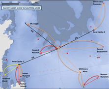
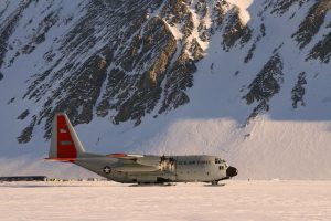 Once again ALE will provide flight and landing support for Twin Otter and ski-equipped C-130 Hercules aircraft, as well as meals and accommodation for flight crews and field staff involved with the POLENET project. The 2014-15 POLENET/ANET field season will consist of servicing existing GPS/seismic stations, installation of three new GPS stations in collaboration with the Italian program, and deployment of a ‘mini-array’ of seismic sensors on the ice sheet in West Antarctica. A team based at ALE’s Union Glacier camp, will service existing stations via Twin Otter. A second team based at the United States Antarctic Program’s WAIS Divide field camp will visit stations in the Amundsen Embayment and Marie Byrd Land sectors for maintenance/data retrieval. In addition a snowmobile traverse, originating from and returning to the WAIS Divide Camp, is planned to deploy an array of 10 seismographs. McMurdo Station will be the hub for servicing existing stations using Twin Otter and helicopter flight support. Coordinated work with the Italian Antarctic program (PNRA) is planned for northern Victoria Land. Using Italian aircraft, and working with Italian team members, 3 GPS systems will be installed at existing GPS monuments.
Visit the POLENET website for lots more info, photos, maps, and educational resources. http://polenet.org
Centro de Estudios Científicos (CECs), Chile
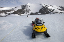
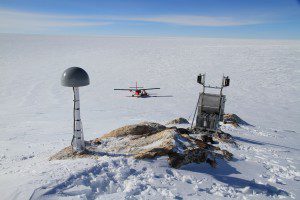
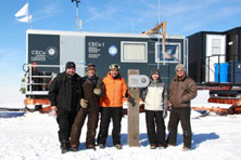 In January 2014, CECs conducted an oversnow traverse to the triple ice divide between Pine Island, Institute and Rutford ice streams in the West Antarctic Ice Sheet (WAIS). The traverse convoy was comprised of a scientific and a logistics module installed on Lehmann sledges and pulled by a Prinoth tractor provided by ALE. In total, the traverse covered near 1100 km (685 miles) from the summer base camp at Union Glacier (79.8ºS/83.4ºW).
The main aim of the campaign was to map the surface and subglacial topography of the region, as well as to identify the internal structure of the ice, and the surface mass balance and ice dynamics. Two different radars operated on a synchronized basis during the long term traverse and the radar data was geolocated using GPS receivers. A network of stakes was installed for mass balance and ice dynamic purposes. A couple of shallow snow/firn cores were also collected.
The team will return to the same area in December 2014 to conduct more detailed surveys of part of the study area.
The West Antarctic Icesheet (WAIS) has been considered potentially unstable, especially Pine Island Glacier, which is the most dynamic in the region and may be experiencing irreversible changes. Little is known about the present and past dynamics at its ice divide with nearby ice streams. Is the ice divide experiencing a migration in response to the lower thinning and ongoing acceleration? Is there evidence within the internal structure of the ice of past dynamic changes? The researchers hope that their data will help answer these questions.
CECs website: http://cecs.cl
Climate Change Research Centre, University of New South Wales, Australia
 Dr. Chris Fogwill and Prof. Chris Turney will fly to Union Glacier with ALE and retrieve equipment stored overwinter. From there the team will travel to Patriot Hills to continue blue-ice sampling begun last season. Blue-ice occurs where strong, turbulent winds remove surface ice in a process known as ablation, drawing ancient, compressed layers up from below. As a result, you can literally walk back through time and access a detailed record of past climate change preserved in millennia-old ice. The duo began sampling in 2013 and have developed a record from the ancient ice that may extend back some 100,000 years at a high resolution. This is truly remarkable and ranks it as one of the best records of past climate in Antarctica. As they develop a detailed age model, they will be able to select different periods in the past and extract the gases from the atmosphere at any point in time, which provides a remarkable insight into how green house gases change through time. This is critical if we are to ever understand the potential changes predicted in the future under increasing CO2.
Dr. Chris Fogwill’s research focuses on the history of the Antarctic ice sheets and their interplay with global climate and sea level. His study of the past dynamic reponse of the Antarctic ice sheets to external forcing over millenia, provides insight into long-term ice sheet dynamics and puts recent observations into perspective.
More about the UNSW Climate Change Research Centre: www.ccrc.unsw.edu.au
Brazilian Antarctic Program – Criosfera 1 and Arctic Trucks Traverse
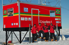 Researchers from the Instituto de Geociências Universidade Federal do Rio Grande do Sul (UFRGS), Brazil will return to Criosfera 1, their standalone module for atmospheric data collection. Early in the season, ALE prepared a skiway and delivered the team’s cargo to the module site. The researchers will fly to Union Glacier in late November and then continue by ALE ski aircraft to Criosfera I. Their plan is to work at the station until early January.
In January, a second team will undertake a 1200 km (746 mile) traverse, supported by ALE, from Criosfera I, past Mount Johns and onward to Union Glacier, expanding the Brazilian Antarctic Programme activities to new areas of the West Antarctic Ice Sheet. They will sample snow and ice for chemical analysis and environmental interpretation, with the aim of looking for links to South American climatic variability.
The Brazilian researchers are particularly interested in the role of aerosols, given that previous studies have pointed to the South American continent as the major contributor to the flow of natural and man-made micro-particulates to Antarctica. Their research will combine uninterrupted monitoring for aerosols and trace gases by automatic stations; and on board monitoring at the South Atlantic and Southern Ocean. The study will be complemented by satellite images and transport models.
Criosfera I was commissioned in 2011 and is one of the few year-round atmospheric monitoring stations in the interior of Antarctica (84ºS/79.3ºW). The meteorological instrumentation measures air temperature, wind speed and direction, relative humidity, atmospheric pressure and solar irradiation. The concentration of carbon dioxide in the air and snow deposition on-site are also measured. The data is accumulated in a “datalogger” and mean values are sent out each hour by satellite. The module perfoms a monthly sampling of aerosols with the objective of analyzing the elemental and ionic composition. Next year (2015) the researchers hope to install a second module Criosfera II near Mount Johns.
The collected data contributes to a better understanding of climate change in Antarctica, including hotly debated topics such as whether meteorological observations indicate a significant increase in the temperature trend of West Antarctica and, if so, what the consequences might be to the albedo, variability of sea ice, retreat of glaciers and changing patterns of ocean currents.
Polar 6 Flights – Alfred Wegener Institute
Crews aboard the Alfred Wegener Institute’s (AWI), Germany, Basler BT-67 Polar 6 will find Union Glacier a welcome place to rest and refuel between survey flights in November and January. Understanding global changes of the environment and the biosphere, either natural or caused by humans, is the primary goal of research work at the Alfred Wegener Institute. www.awi.de/en/home/
British Antarctic Survey (BAS)
 The British Antarctic Survey (BAS) is undertaking a number of interesting projects in West Antarctica and one of the field teams, ‘Sledge Charlie,’ will use Union Glacier as a hub for their field work. This BAS team will re-visit GPS receivers installed in 2013 to measure crustal uplift over several seasons. Their work contributes to iSTAR D: The contribution to sea-level rise of the Amundsen Sea sector of Antarctica.
iSTAR D aims to determine the thinning history of the Amundsen Sea glacier and its surroundings, then use this information to better estimate how much ice is being lost today. The work is significant as this part of Antarctica is currently is the single most important contributor to sea level rise from the continent. Ice mass changes are measured over several years, but these measurements need to be corrected for the rebound of the Earth’s crust after de-glaciation, a process called glacial-isostatic adjustment (GIA). Researchers are working to develop a better model of GIA and thus improve estimates of the ongoing contribution to sea-level rise of this part of Antarctica. Other iSTAR D work aims to improve techniques for measuring ice mass loss. Once the researchers know how much ice was lost from the area and when, they can input these data to models which simulate the crustal rebound of the Earth following de-glaciation. They can determine if the model is any good by comparing the rates predicted by the model to actual GPS uplift measurements.
2013 Project Objectives:
- Identify landforms and features that indicate ice sheet thinning, at sites in the deep interior of the West Antarctic Ice Sheet
- Date this evidence by sampling bedrock and glacial erratic boulders
- Install GPS receivers to measure crustal uplift over the next few years (separate field team based at Union Glacier)
This year (2014) engineer Matt Ashley will revisit the GPS sites to download the data.
Account of last year’s GPS fieldwork: www.istar.ac.uk/2014/02/24/the-istar-d-team-describe-how-their-mission-went/
More about BAS Polar Science: www.bas.ac.uk/bas_research/science/index.php